
Map-case YLTAD 28 DRAWER 105/10
Container
Contains 40 Results:
Panoramic elevation, pencil rendering of development for two blocks of 4 single storey units and two blocks of 8 double storey units and site plan, ., [between 1951 and 1989?]
Digital

Item — map-case: YLTAD 28 DRAWER 105/10
Identifier(s): YLTAD28/69/1
Dates:
[between 1951 and 1989?]
Found in:
Pictures Collection, State Library Victoria
/
YLTAD 28, Collection of architectural drawings mostly for earth houses in Melbourne and Victoria
/
Residences
/
Victoria
/
Eltham
/
View from Mt Pleasant Road development, Mt Pleasant Road, Eltham, for Mrs. Treganowan
Plan, elevations, section A and section through wall, 1962 February 1
Digital

Item — map-case: YLTAD 28 DRAWER 105/10
Identifier(s): YLTAD28/48/1
Dates:
1962 February 1
Found in:
Pictures Collection, State Library Victoria
/
YLTAD 28, Collection of architectural drawings mostly for earth houses in Melbourne and Victoria
/
Residences
/
Victoria
/
Montmorency
/
Extension to house, 13 Calrossie Avenue, Montmorency, for Mr and Mrs A.J. Pittard
Concrete details, 1962 February 1
Digital

Item — map-case: YLTAD 28 DRAWER 105/10
Identifier(s): YLTAD28/48/2
Dates:
1962 February 1
Found in:
Pictures Collection, State Library Victoria
/
YLTAD 28, Collection of architectural drawings mostly for earth houses in Melbourne and Victoria
/
Residences
/
Victoria
/
Montmorency
/
Extension to house, 13 Calrossie Avenue, Montmorency, for Mr and Mrs A.J. Pittard
Structural computations, 1962 February 1
Digital

Item — map-case: YLTAD 28 DRAWER 105/10
Identifier(s): YLTAD28/48/3
Dates:
1962 February 1
Found in:
Pictures Collection, State Library Victoria
/
YLTAD 28, Collection of architectural drawings mostly for earth houses in Melbourne and Victoria
/
Residences
/
Victoria
/
Montmorency
/
Extension to house, 13 Calrossie Avenue, Montmorency, for Mr and Mrs A.J. Pittard
Sketch plan, [between 1951 and 1989?]
Digital
Item — map-case: YLTAD 28 DRAWER 105/10
Identifier(s): YLTAD28/39/1
Dates:
[between 1951 and 1989?]
Found in:
Pictures Collection, State Library Victoria
/
YLTAD 28, Collection of architectural drawings mostly for earth houses in Melbourne and Victoria
/
Residences
/
Victoria
/
Mount Waverley
/
Mielke house, Lot 40 Stephensons Road, Mt Waverley
McMahon house, [between 1951 and 1989?]
Digital

Item — map-case: YLTAD 28 DRAWER 105/10
Identifier(s): YLTAD28/38/1
Dates:
[between 1951 and 1989?]
Found in:
Pictures Collection, State Library Victoria
/
YLTAD 28, Collection of architectural drawings mostly for earth houses in Melbourne and Victoria
/
Residences
/
Unidentified location
/
McMahon house
Sketch plan, [between 1951 and 1989?]
Digital

Item — map-case: YLTAD 28 DRAWER 105/10
Identifier(s): YLTAD28/57/1
Dates:
[between 1951 and 1989?]
Found in:
Pictures Collection, State Library Victoria
/
YLTAD 28, Collection of architectural drawings mostly for earth houses in Melbourne and Victoria
/
Residences
/
Unidentified location
/
Severn house
Sketch plan, [between 1951 and 1989?]
Digital

Item — map-case: YLTAD 28 DRAWER 105/10
Identifier(s): YLTAD28/68/1
Dates:
[between 1951 and 1989?]
Found in:
Pictures Collection, State Library Victoria
/
YLTAD 28, Collection of architectural drawings mostly for earth houses in Melbourne and Victoria
/
Residences
/
Unidentified location
/
Trebilcock, 19.5 squares
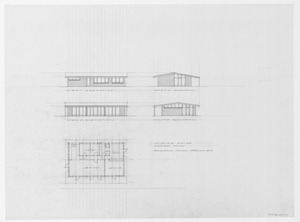
Plan and two elevations, [between 1951 and 1989?]
Digital

Item — map-case: YLTAD 28 DRAWER 105/10
Identifier(s): YLTAD28/70/1
Dates:
[between 1951 and 1989?]
Found in:
Pictures Collection, State Library Victoria
/
YLTAD 28, Collection of architectural drawings mostly for earth houses in Melbourne and Victoria
/
Residences
/
Unidentified location
/
Unidentified job
Plan variation and side elevation, [between 1951 and 1989?]
Digital

Item — map-case: YLTAD 28 DRAWER 105/10
Identifier(s): YLTAD28/70/2
Dates:
[between 1951 and 1989?]
Found in:
Pictures Collection, State Library Victoria
/
YLTAD 28, Collection of architectural drawings mostly for earth houses in Melbourne and Victoria
/
Residences
/
Unidentified location
/
Unidentified job